How Drone Surveys Are Revolutionizing Property Assessment
Angel Surveyors combines traditional chartered surveyor expertise with cutting-edge technology including drone surveys and 3D laser scanning. This innovative approach delivers comprehensive property assessments that were impossible just years ago. Learn how advanced surveying technology benefits property buyers, sellers, and investors across London.
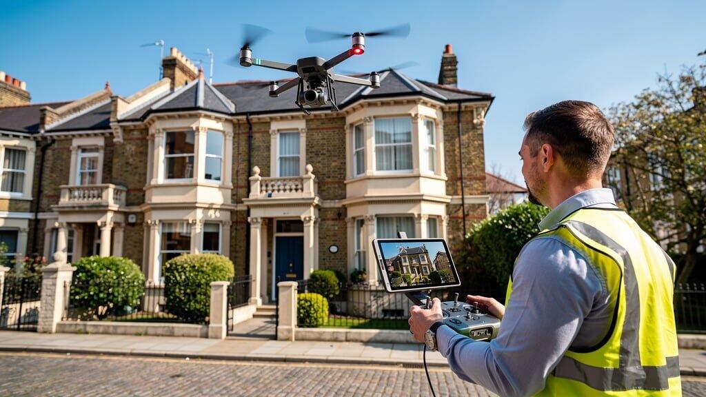
What Are Drone Surveys?
Drone surveys use unmanned aerial vehicles (UAVs) equipped with high-resolution cameras and sensors to inspect property exteriors, particularly roofs and high-level elements. Angel Surveyors' drone surveys provide detailed imagery without scaffolding or dangerous access methods.
Our RICS chartered surveyors pilot advanced drones capturing thousands of high-resolution images during inspections. These reveal defects invisible from ground level, providing comprehensive property assessments for building surveys across London.
Benefits of Drone Surveys for Property Assessment
Safe Inspection of Dangerous Areas
Traditional roof inspections require ladders or scaffolding creating safety risks and high costs. Angel Surveyors' drone surveys access roofs, chimneys, and high walls safely from ground level. Our building surveyors obtain detailed analysis without physical access.
Cost-Effective Technology
Scaffolding for property inspection can cost thousands. Drone surveys technology eliminates these expenses while providing superior image quality. Clients receive professional property surveying services at reduced costs with enhanced detail.
Detailed Visual Evidence
High-resolution drone imagery shows minute details like cracked tiles, damaged flashing, and gutter problems. Our drone surveys and 3D laser scanning create permanent records of property condition useful for insurance, maintenance planning, and future reference.
Faster Inspections
Traditional roof surveys take hours setting up access equipment. Angel Surveyors' experienced team completes drone surveys in minutes, reducing disruption while maintaining comprehensive coverage. Professional surveying services delivered efficiently.
Hard-to-Access Properties
Listed buildings, conservation area properties, and sites with access constraints benefit enormously. Technology including drone surveys enables thorough inspection where traditional methods fail.
3D Laser Scanning Integration
Angel Surveyors combines drone surveys and 3D laser scanning for measured building surveys. This advanced surveying technology captures millions of data points creating accurate digital models of buildings.
Measured Building Surveys
Architects, engineers, and developers require precise measurements. Our surveys and 3D laser scanning deliver CAD drawings, BIM models, and point cloud data for construction projects and refurbishment projects across London.
Heritage Documentation
Listed buildings need careful documentation. Professional 3D laser scanning preserves historic architecture digitally, essential for conservation planning and restoration work.
Renovation Planning
Planning extensions or renovations requires accurate existing condition data. Angel Surveyors' advanced surveying technology provides detailed measurements and analysis supporting project management services for construction.
What Drone Surveys Can Identify
Our professional property surveying services using drone technology identify:
- Roof defects: Missing tiles, cracked slates, valley problems
- Chimney issues: Leaning stacks, missing pots, deteriorating mortar
- Gutter problems: Blockages, leaks, improper falls
- Flat roof condition: Bubbling, cracking, pooling water
- Parapet walls: Coping stone issues, damp penetration
- Lead work: Valley deterioration, flashing failures
- Structural movement: Wall bulging, separation at junctions
- Building defects: Render problems, masonry decay
Thermal Imaging Capabilities
Advanced drone surveys include thermal imaging cameras identifying:
- Heat loss and insulation gaps
- Moisture penetration and damp problems
- Electrical hotspots indicating faults
- Air leakage points reducing energy efficiency
This cutting-edge technology enhances Angel Surveyors' comprehensive property assessments, particularly valuable for energy efficiency surveys and building defect analysis.
Drone Surveys in Different Property Types
Victorian Properties
London's Victorian properties feature complex roofs, tall chimneys, and ornate details. Drone surveys technology captures these elements safely, identifying issues common in period buildings our building surveyors understand well.
Commercial Property
Large commercial property buildings benefit from aerial surveys providing overview photography and detailed section inspection. Professional property assessment identifies maintenance needs across extensive roof areas.
Listed Buildings
Conservation requirements often restrict access to listed buildings. Our drone surveys and 3D laser scanning document heritage properties comprehensively without invasive access methods, respecting architectural significance.
New Build Developments
Snagging surveys for new builds include drone inspection verifying roof construction quality. Angel Surveyors identifies defects developers must rectify before completion.
Regulatory Compliance
Angel Surveyors operates drone surveys within UK Civil Aviation Authority regulations:
- All pilots hold CAA certifications
- Flights comply with airspace restrictions
- Full public liability insurance coverage
- Risk assessments for every survey location
- Privacy and data protection compliance
Our professional surveying services maintain the highest safety and legal standards while delivering superior results through advanced surveying technology.
How Angel Surveyors Integrates Drone Technology
Our building surveys combine traditional expertise with technology:
Pre-Flight Planning
Chartered surveyors review property details, identify areas requiring close inspection, and plan flight paths. Experienced team members understand what drone imagery should capture for comprehensive analysis.
Ground-Level Inspection
Traditional survey methods remain essential. Our RICS chartered surveyors physically inspect accessible areas while drones handle dangerous or inaccessible zones.
Drone Data Collection
Professional drone surveys capture hundreds of high-resolution images from multiple angles. Thermal imaging adds another analysis layer when required.
Expert Analysis
Building surveyors review all imagery identifying defects, assessing severity, and providing repair recommendations. Advanced surveying technology enhances but doesn't replace chartered surveyor expertise.
Comprehensive Reporting
Survey reports include selected drone images with annotations explaining findings. Clients receive detailed analysis of property condition with visual evidence supporting recommendations.
Future of Surveying Technology
Angel Surveyors stays at the forefront of surveying innovation:
- AI-assisted defect identification
- Automated measurement from imagery
- Enhanced thermal and multispectral sensors
- Integrated BIM model generation
- Virtual reality property walkthroughs
Our commitment to cutting-edge technology ensures clients receive the most comprehensive property assessments available. Traditional chartered surveyor expertise combined with advanced tools delivers unmatched professional property surveying services.
Experience Advanced Surveying Technology
Contact Angel Surveyors to learn how drone surveys and 3D laser scanning enhance building surveys for your London property. Our RICS chartered surveyors provide professional property assessment using the latest technology.
Request Drone Survey📋 Explore Our Services
Discover our comprehensive Advanced Drone Survey Services delivered by experienced RICS chartered surveyors across London.